Wednesday, 17 August 2016

RouteShoot Android Version 1.0.8 Update

We’re happy to announce that we've just released another update for Android. 

Here's what’s new:
  • Map Changed to Overlay with Transparency
  • Updated Button Styles
  • YouTube option Removed
  • In-app Purchases Removed
  • Upload Dialogue displaying units in mb if file size is over 1mb
  • Drop Down Selection added for recording limit
  • Rotation Support
  • Bitrate Slider
You can download the RouteShoot Android App by clicking here:


Monday, 15 August 2016

RouteShoot iOS 1.4.0 Update

We are pleased to announce that version 1.4.0 of the RouteShoot app for iOS is now available on the App Store.

The update addresses some user concerns and improves overall user experience.

HIGHLIGHTS
  • Various bug fixes
  • Pinch to Zoom - Supports zoom before and during recording.
  • Title Prompt - Controlled within the settings, this can be turned on or off. When turned on, a prompt when the record button is pressed will appear and the user will be able input the relevant ticket number prior to the recording starting. This feature will be mostly beneficial when using the multiple upload feature as all videos will already be named in the files list.
  • Multiple Upload - Users will now have the ability to upload all recordings at any one time or select any outstanding. The app will also recognise what videos have already been successfully uploaded meaning you won't accidentally upload them for a second time.
  • Image Quality - The amount of image quality recording options available to the user have increased.
  • Colour Coding - Successfully Uploaded, Failed Upload, Not Attempted Upload.
  • Record Time - The options available to the user (should they wish to limit each video recording) have increased offering a range from 5 minutes up to unlimited.
Download the RouteShoot app from the app store now by clicking the button below! 


Wednesday, 29 June 2016

RouteShoot Highly Commended for Product of the Year

Following selection by Alarm - the public risk management association, as a finalist in their Product of the Year 2016 award, RouteShoot Ltd are very pleased to announce that our geo-referenced video solution has been ‘Highly Commended’ by the 27 strong judging panel drawn from experienced professionals within the risk and insurance community. 

The awards, which were held in Manchester on the 27th June 2016 and hosted by professional risk-taker, Caspar Berry, are highly regarded as a measure of excellence within public risk management.


The award for excellence recognises those products and solutions that have delivered real value to organisations, and acknowledges the significance of RouteShoot’s contribution in driving efficiency for the public sector risk management. During the award announcement, RouteShoot was particularly highlighted for our contribution to the management of risk within the asset infrastructure management industry.


Gary Wilson, MD of RouteShoot Ltd, commented: “We are delighted to have been recognised by Alarm for the vital role that RouteShoot plays in reducing and managing risk in the public sector. This is a particularly timely award on the day that we have confirmed yet another large scale deployment of RouteShoot, this time with the Performance Audit Group (PAGplus) who work with Transport Scotland and their agents to monitor condition on the Motorway and Trunk Road network throughout Scotland”


Congratulations to the RouteShoot team on successfully achieving 'Highly Commended' in the 'Product of the Year' category at the 2016 Alarm Risk Awards. The standard of applications was once again extremely high and we are tremendously proud of our result.

We'd also like to congratulate Dorset County Council on achieving 'Highly Commended' in the 'Strategic Award' category.

Wednesday, 25 May 2016

RouteShoot Shortlisted for Alarm Risk Awards 2016 Product of the Year Award

RouteShoot Limited is thrilled to announce that our GPS Tagged Video platform has been shortlisted for the Product of the Year Award! Winners will be announced at the Alarm Risk Awards Dinner being held at the Palace Hotel, Manchester on the 27th June 2016. 


The Alarm Risk Awards celebrate those public service and community organisations who have maintained effective and innovative forward momentum in the management of risk. 

This Product of the Year Award recognises those companies who have provided an effective product or solution that has assisted public service or community organisations in managing their risks. 

Monday, 9 May 2016

Aerial Surveillance and Spatial Multimedia

Waterways, Pipelines, electrical transmission lines and railroads all require inspection of assets.

The aerial survey has emerged as a credible solution.


Now, the use of video and digital photographs as well as its audio commentary is an invaluable tool for documentation and communication. Helicopter patrol and video recording is now an industry norm. The recordings extend the time in which visual assessment can be conducted and potentially enable the cooperative review of asset conditions by a body of expert inspectors.

With many of these patrols the video remains recorded to tape. While this format is reliable and seemingly low cost it can only be forced to recall detail with some difficulty. Therefore, tape based systems are changing to digital forms. When digital multimedia is accepted, all sorts of enterprise information can be associated with that content.

Geotagging, sometimes referred to as Geocoding, is the process of adding geographical identification to various media such as images, or video. This data usually consists of latitude and longitude coordinates, though it can also include altitude, bearing, place names, and other data.

RouteShoot uniquely complements that commitment to this technical change. And it is this spatial indexing of video patrols that radically shifts the utility of the visual inventory. Once spatialised as a set of map-indexed patrol pathways, the current and past conditions of the corridor landscape and its infrastructures can be shared and intuitively accessed across the organisation.

RouteShoot provides a solid foundation for geographically disperse asset management and timely decision support without incurring the expense associated with multiple on-site visits. Because the mapped multimedia content is available over a network, everyone in an organisation has simultaneous access to the store of information.

Thursday, 28 April 2016

Geo-referenced Spatial Multimedia Application

There has always been a gap between map features and representation and visualisation in GIS maps.

This gap is now being filled by spatial multimedia. Spatial Multimedia brings geo-referenced video multimedia and digital, interactive mapping capabilities to the desktop of the planning professionals.

Transportation planners and other environmental agencies face enormous challenges in monitoring and interpreting traffic situations on daily basis. The implementation of Spatial Multimedia Applications with geo-referenced video images is seen as key to meeting these challenges.


The ability to visually explore and navigate these dynamic scenarios through video imagery is an important function of Spatial Multimedia. Hence, the use of Video mapping or geo-referencing in Spatial Multimedia applications has become vital in the representation and visualisation of planning scenarios, especially in traffic situations. 

It has recently become a lucrative component of the mapping industry because of its ability to extend the cognitive abilities of planners and enhance consensus on issues amongst and across levels of decision makers.


It doesn't stop there though. Spatial Multimedia can be used across an array of sectors including:

Municipalities


Municipalities for managing its civic amenities in many cities. The application of Spatial Multimedia would be highly useful for this purpose.
  • Asset inventory
  • Maintenance planning
  • Quality assurance

Utilities


Water, Sewer, Gas pipeline and electric utilities have started using Spatial Multimedia technologies for the operation, management, and servicing of assets.

RouteShoot provides the utility market with a highly versatile, cost-effective, and easily integrated solution that enables better decision-making. We offer a fully automated process for the geo-referencing and mapping of digital photographs, video, and audio. More importantly, we provide you with tools that dramatically enhance the use and sharing of field data - right from your desktop.


Transport and Engineering


  • Rail Track Management
  • Highway maintenance
  • Site surveying
  • Construction phase reporting and monitoring
  • Asset Management

Tuesday, 26 April 2016

From Drone to the Field

Unmanned Aerial Vehicles (UAVs) are becoming the go to technology in the mapping business for collecting aerial imagery.

UAVs have quickly become a truly disruptive technology in the geospatial industry. The ability to quickly send an inexpensive and flexible platform of sensors into the air to survey your surroundings, and receive near real time feedback, has opened the door to countless opportunities for data collection and analytics.


We see UAV technology as a major opportunity to enhance both the efficiency and the quality of data collected in the field. In order to keep ahead of this technology, our development team have spent some time over the past few weeks looking into how RouteShoot can support the ever growing file formats produced by UAV's.

The processes are still in development, but we’re making considerable progress in showcasing how readily UAV-based imagery can be deployed on the ground in real-world scenarios for various operations.

Tuesday, 1 March 2016

Local Road Financing Innovations in the Philippines

Access to global markets can move a new business from a backyard garage to a local warehouse to a global network. In fact, small businesses that export are more productive, have greater job growth and are more likely to stay financially solvent than non-exporters.

In 2014 RouteShoot were contacted by the World Bank who were seeking a collaborative tool that would assist in the monitoring of strategic investments in local roads in the Philippines. The World Bank is a United Nations international financial institution that provides loans to developing countries for capital programs, with a membership of 188 countries, 6 official languages and 12,000 plus staff and consultants who work in Washington, DC and in more than 130 countries worldwide.

The Department for Public Works and Highways (DPWH) vowed to further upgrade and fully pave the national network, and finance, implement, and monitor strategic investments in local roads in the Philippines. The current Aquino administration, governing from mid-2010 to 2016, has prioritised over $3billion for Farm to Market Roads (FMRs) and Tourism Road Infrastructure (TRIP) alone.

In August 2014 the World Bank approved the Philippines Rural Development Program (PRDP), of which the majority of the $500million financing is allocated for FMRs. The Rural Development Project for the Philippines aims to increase rural incomes and enhance farm and fishery productivity in targeted areas by supporting smallholders and fishers to increase their marketable surpluses and their access to markets.

The Philippines, and for that matter most local governments, have no comprehensive, open, and validated map to their road network and those levels of government responsible for it. Main road investment programs have historically been both opaque and highly politicised. Project budget credibility has been weak, with roads being apparently funded not getting built. Tracking public roads investments from budgeting, procurement, implementation, audit, and maintenance has more often than not been a broken chain.

In September 2014 RouteShoot partnered with web developers out in the Philippines to create an on-line interactive, Open Government, multi-media platform to digitally map the whole national and local roads network in the Philippines, and track associated priority public investment projects.

The platform called 'Open Roads' captures geo-coded digital images and videos through notably mobile devices to promote better planning, budgeting, procurement, implementation, and participatory audits. More timely and better information across the public investment delivery chain provides the basis for closing feedback and performance monitoring loops. RouteShoot has now become a government mandated tool that must be used as part of the project management process across the the Philippine archipelago comprising 7,107 islands. 

In February 2016, RouteShoot and the World Bank signed a new extension to the contract which saw a couple of our team heading out to visit the guys in the Philippines. A blog post published by the World Bank discussing 'Local road financing innovations in the Philippiness' can be found here:

Monday, 29 February 2016

Announcing Expanded Features

RouteShoot sees the release of some brand new features. The entire RouteShoot team has remained focused and operated with purpose over the past year to bring you some highly powerful features!


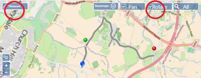
Route List:
In the top left hand corner of the journal map you will notice there is a 'route list'. By clicking the drop down menu this will allow you to quickly select from a list of routes that have been randomly colour coordinated for visual ease.


Rotate:
When selected, the rotate feature orientates the map so that the direction of travel is always upwards. 

Measuring Tool:
Use the measuring tool to draw a line or polygon on the map to determine the geographic length or area.


We’re blown away by how RouteShoot has grown recently and we’re excited to evolve it even further in the coming year. 

Tuesday, 2 February 2016

RouteShoot - Geo-referenced Video For Everyone

Video capture has historically been costly, requiring dedicated cameras and hardware. In order to conduct roadway alignment surveys, or construction site reviews using video documentation, it involved loaning out extremely expensive equipment to surveyors, then waiting to pull together the data manually in the back-office for review.

Using consumer-grade hardware (like Android devices or iPhones), teams can use the device they carry everywhere to document quick clips, or mount the device in their vehicle to drive the length of a road widening project, then sync everything they’ve captured up to the centralised cloud account for management and review. RouteShoot even has an option to record the audio track with the video, so an inspector can make voice annotations and comments as they’re walking a construction site or a facility inspection.

Within the RouteShoot iOS and Android apps, you also have total control over video quality, both resolution and frame rate. Based on your needs, being able to adjust quality gives you a way to manage file sizes and storage.

Along with the GPS location track, our video recorder also logs the heading, time, speed, distance, and even the altitude. 

Combined with high-resolution imagery, this allows you to identify buildings, road signs, poles, and lots more right from the imagery as you’re scrubbing through your collected video. 


With high definition video, pausing the clip gives you nice crisp frames for picking out features.

Check out the 'Edition Comparison' page to see which plan is right for you to get started using video capture. Also grab the latest updates to the iOS or Android app to get access from mobile, including a host of other new features.

Stay tuned to the blog and follow us on Twitter for more news on additional announcements.

Wednesday, 20 January 2016

Creative England 50 2016 - RouteShoot Made the List!

England’s 50 most creative businesses have been showcased in a landmark report by Creative England, and we made the list!

RouteShoot FD Adam May is off to London today to attend the Creative England 50 event, celebrating the most innovative businesses in the creative industry!


We’re very pleased to be included in the list alongside some really big names and the RouteShoot bosses are looking forward to the RouteShoot product being showcased.

The event has also been covered in the Telegraph!

To read more about the report: Click Here

Monday, 30 November 2015

RouteShoot moves to Exeter Science Park

RouteShoot is excited to announce that it will be making it's move this week into the state-of-the-art, UK’s 70th and newest Science Park – following on from their successful Exeter R&D Center set up.

RouteShoot; who were based at the Innovation Centre in Exeter until November 2015, will be moving to the Exeter Science Park on the 1st December. The new Centre has been designed to facilitate ‘open Innovation’ collaborative working to support the growth of R&D-intensive businesses and is one of several elements which make up the Exeter and East Devon Growth Point.


The move comes at an exciting time for RouteShoot; as they are currently moving into new markets.

The company, founded in 2012, offers the latest innovation in Geo-referenced video, route tracking and collaborative working.

Its innovative approach is a combination of the RouteShoot smartphone application and a dedicated website, which allows users to monitor their infrastructure across the world and share their Geo-referenced video with colleagues, customers and other stakeholders.


Exeter and the South West demonstrate a track record in innovation and entrepreneurship, where start-ups have attracted more than $550 million in investment and returned more than $800 million to shareholders.

The South West combines innovation and technology excellence, a great mix of universities with both academic and venture focus and an established reputation in attracting leading tech firms while providing great incubation and support for earlier stage business.

Tuesday, 24 November 2015

RouteShoot appointed to G-Cloud 7 Framework

What is better than being on cloud nine? Perhaps being on G-Cloud 7...

UK-based Geo-referenced video specialist RouteShoot has been awarded a place on the latest UK Government’s G-Cloud framework, RM1557vii for its market leading Smartphone app and GPS tagged video solution.


Inclusion within the Crown Commercial Service (CCS) framework will allow RouteShoot to offer its pioneering technology to the public sector under the category of Software as a Service (SaaS).

G-Cloud is an innovative framework which offers the most up to date cloud services available for the public sector. Distinctly, instead of paying for services which bind people to inflexible and long-term contracts, subscribers to G-Cloud pay for services as they use them. Such services can be bought through 'Cloud Store' which is now known as the 'Digital Marketplace'.

The key role and the leading purpose of G-Cloud is to encourage and make it much easier for a number of public sector organisations, local authorities, government branches and NHS to call-off different cloud-based services. This framework also aims to provide UK businesses the necessary package of opportunities that will help them win UK Government contracts. By enabling the public sector organisations to access and subscribe to internet-based computing, G-Cloud 7 excludes the need for investing in traditional self delivered IT solutions. The effortless and cost-effective way to access and benefit from computing resources via a framework agreement turns G-Cloud into commodity-based ‘scaffolding’ that covers infrastructure, platform, software and specialist cloud services. The agility and rapid deployment of pay as you go cloud services guarantee's the ultimate value and the quality of service delivery.

Since its conception in 2012 the G-Cloud initiative has made it mandatory for central government to adopt a “cloud first” policy. This policy dictates the consideration of cloud-based IT solutions before other options and encourages the public sector to do this by providing a list of pre-approved suppliers and the ability for consumers to search by various technology attributes.

Gary Wilson Director at RouteShoot said: ‘We are incredibly proud to have been awarded a place on G-Cloud 7. Our services are now in front of the right people in the right organisations, streamlining our service provisions to the public service.’

RouteShoot has an established track record and ongoing pipeline of work to help the public sector manage its risk, reduce costs and save time.

RouteShoot's full offering can be found on the Digital Marketplace G-Cloud framework page.

Monday, 5 October 2015

Avoid Roaming Charges and still use RouteShoot abroad this winter

Worried about roaming charges on your winter sports holiday? 

By planning ahead it is possible to have maps and GPS positioning on your phone without incurring data charges.


Most smartphones data roam by default, and this allows you to get instant notifications from apps such as Facebook and Twitter. However you can turn this off and still use RouteShoot, which, unlike Google Maps, does not require data roaming.

Top tips for using your phone abroad:

Switch off data roaming:

  • iPhone – Settings > General > Cellular > Data Roaming – Off.
  • Android – Uncheck data roaming at Settings>Wireless & Networks >Mobile Networks.

If you want to use data roaming when abroad:

Contact your network provider to talk about data bundles available to purchase.

Maintain battery power:

If you have taken your phone abroad in case of an emergency, battery power is essential. Reducing the brightness of your screen and closing any apps running in the background will increase your battery life.

Use free Wi-Fi:

Identify a cafe or restaurant offering free Wi-Fi and use this to do any data applications, such as checking your emails, or social media.

Buy a local sim card:

If you are staying for a long period of time consider purchasing a local pay as you go sim card with a pre-installed data bundle.

Monday, 21 September 2015

Interactive School Bus Route Mapping

The simplest ideas are often the most effective. Our interactive bus route maps for schools are just what parents want.

As an operator who offers a school bus service, one of the issues you may face is explaining your routes to parents and pupils. After speaking with other service providers, most tend to provide either printed or digital maps of the routes available, but find that young school children often don't know the local area well enough to interpret the maps. Therefore, operators have been looking for another way of showing this information. 


RouteShoot allows you to record the routes using a free, easy to download smartphone app and play them back alongside a map. Accessing the data captured via your very own website, with videos publicly available to both parents and pupils.

Locate your collection point on the map, click on the route and the area related to your stop is clearly shown.

Our interactive Bus Routes are for any school with any amount of routes. Yes it is simple and effective and low cost to implement!

Thursday, 3 September 2015

RouteShoot for Disaster Relief

The capabilities, efficient team collaboration, and flexibility of RouteShoot can be easily leveraged for disaster preparation, response, and relief efforts. Any form of disaster preparation requires plenty of data collection, and RouteShoot is a great, cost efficient alternative to other GPS equipment. In addition, RouteShoot can be used for collecting infrastructure information, documenting homes for insurance purposes before a storm, and so much more.

After a disaster, RouteShoot can be quickly deployed to the field with minimal training and preparation; and since most people have smart phones or tablets anyway, there’s no need to obtain any equipment — and the “bring your own device” model that crisis response agencies need becomes a reality.


RouteShoot users (whether organisation employees or volunteers) can be in the field reporting damage the minute a storm has passed, even if cellular networks are down. Data collected pre-storm, coupled with post-storm assessment information can greatly aid in relief efforts. RouteShoot allows for data to be uploaded in near real time, so someone sitting at a relief organisation’s HQ can be monitoring the damage as soon as field users sync their collected data.

If you think RouteShoot could help assist your relief efforts, be sure to get in touch for a demo to see a field solution ready for rapid and effective deployment.

We will be happy to answer any questions you may have about RouteShoot and how to make use of it before and after an event.

Monday, 17 August 2015

Unleashing Equestrian Potential

A horse riders companion; ride and record your route, share with friends and family, edit and view online.

Once you have stopped recording you can then save and share your rides with friends via Email or Social Media. You can also view and edit your rides via the www.RouteShoot.com website.

Main Features:
  • Videos get stored in the Cloud, so they won’t affect your phones storage
  • Record in SD or HD and measure the course
  • Photograph jumps, video lines and record audio all plotted alongside a route
  • Capture statistics including speed, elevation, distance and time
  • Enable bookmarks to capture up to 3 different types of 'Point' and 'Linear' points of interest
  • Available internationally for iOS, Android and Windows
  • Free to download
Create an equestrian course map by combining video and GPS straight from your Smartphone. 

RouteShoot is a combination of the RouteShoot website and the RouteShoot mobile application, which allows users to share their favourite routes with friends, family and those with similar interests.

RouteShoot helps riders review data using our web-based visualisation tools and access video playback alongside its route.

Visit www.RouteShoot.com now for your free 30 day trial.

Monday, 10 August 2015

Corporate Governance and RouteShoot

The administration of local road networks in countries which are largely poor and fragmented has put a drag on inclusive growth prospects, weighing on farmer fisheries and tourism development.

National governments are now launching national programs to upgrade national and local road networks, but there are major challenges in realising the strategic roads investments vision.

Most local governments, have no comprehensive, open, and validated map to their road network. Main road investment programs have historically been both opaque and highly politicised. Tracking public roads investments from budgeting, procurement, implementation, audit, and maintenance has more often than not been a broken chain.

With governance and public infrastructure delivery challenges on a vast scale there are no silver bullets, but better information and stakeholder information and engagement will clearly need to be an ingredient of this effort.

Our infographic below details the cycle of how RouteShoot is helping contribute to that aim with the World Bank out in the Philippines.


Friday, 24 July 2015

RouteShoot in Vanuatu

RouteShoot are delighted to welcome on-board our client from Vanuatu.

Port Vila Urban Development Project is a Donor funded project that is currently 80% of the way through the detailed design, with construction due to start in a few months.

Over the past 12 months, the design of all the road upgrading, drainage and sanitation under the project has been finalised in preparation for the construction of roads and drainage facilities. 

The project is the most significant investment in the country since independence 33 years ago and is a jointly funded initiative of the Government of Vanuatu, Australian Aid and the Asian Development Bank.


The Challenge


The Design, Supervision and Capacity Development Team working out in Vanuatu on the Port Vila Urban Development Project were looking for a tablet application with the ability to quickly and easily record video of a road related design and construction activity, and then have the information available via a map.

''RouteShoot's platform has proven very useful during the design stage of the project, allowing designers and drafters quick and easy reference to the physical landscape''.

During construction activities, it is proposed that supervision teams would have the ability to record construction issues out in the field, aswell as add comments and flags (such as Contract Variation and defects), whilst Community liaison teams back in the office needed to be able to record details and again log various further action.

Before RouteShoot


Prior to RouteShoot the team out in Vanuatu were capturing data via digital cameras and still data was filed in generic style filing formats. The volume of data collection and management as well as their need to complete projects efficiently was restricted by the delay between collecting data in the field and analysing it back at office to determine the next steps of their projects.

Now...


Data collection, observations, and general management of the Port Vila Urban Development Project now operates in near real-time and this has changed things significantly for the project team.

Further to this, RouteShoot has also been used in recently presenting to the client where a projection of the design model was viewed in conjunction with Route Shoot video and map presentation.

Wednesday, 8 July 2015

RouteShoot Infographic by the Numbers

In early 2012, developments in technology - which saw full 1080p HD video recording incorporated into a smartphone (such as the iPhone 4) - meant that it became possible to achieve what several specialist companies offer using just the everyday devices available in most people’s pockets.

RouteShoot was born!

We give you the numbers so far...

Sign up for a 30 day free trial of RouteShoot and see what you can make of your mobile data capture!