Thursday, 21 May 2015

The RouteShoot Platform Gets a Design Refresh

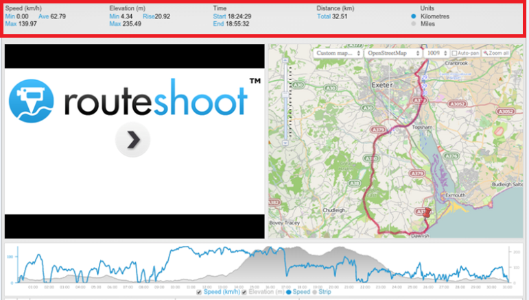
Frequent users may have noticed that the RouteShoot platform got a bit of a facelift recently. We originally went with the tried and true 'numbers in a line' layout in the main header, consisting of Speed, Elevation, Time and Distance.


However, we felt there was a certain lack of joy in the design of the old layout. There wasn’t necessarily anything wrong with it, but it didn't make make us feel pleased when we looked at it.

The rework began, the desire being to make the captured data a little more...shall we say...aesthetically pleasing, aswell as offering more information!

In doing so we replaced the Speed, Elevation, Time and Distance numbers with dials and summarised a display of captured statistics including:
  • Video Title
  • Location Address
  • Long/Lat Coordinates
  • Time & Date Stamp
As a result of the changes, the information captured is now available in an instant snap shot!


While we’re always making incremental improvements to the site, it’s nice to give things an overhaul now and then when they fall behind. Even something as straightforward as a design refresh can have many areas ripe for improvement when you focus on what really matters.

Check back with us in the coming weeks and months to see what else we send to the cutting room floor.

Wednesday, 20 May 2015

Tips to help you get the most out of your Mobile Device.

So here you are trying to keep up with the ever-changing technology and you recently started to collect your data digitally though your Smartphone or tablet device. Beside all of the great advantages that this change has, you will probably quickly realise a few not so great things. 

The battery can drain quickly when the device is constantly being used.  The more you use your mobile device, the more prone you are to dropping and damaging it. 

The goal of this blog post is to provide RouteShoot users some solutions to these problems.

Maximize battery life

Out of all the problems, short battery life is probably the most common. Spending long days away from a power outlet or vehicle can leave you with little to no battery power on your smart device. Data collection done on your cell phone makes this even more of an issue. Here are some simple steps you can take to help retain power throughout the day.

Features like Bluetooth and Wi-Fi are great but if you are not using it then it is unnecessarily draining your battery. Turn these features off when they are not in use.
If you are going to be working in a remote place where you know you will not have a data signal, turn off you data connection. Important Note: I would not recommend simply turning on airplane mode, because this mode turns off the internal GPS.

Close any apps running in the background. For iOS devices (iPhone/iPad), double-click the Home button to view the multitasking bar. Then swipe the apps upwards to close the apps running in the background. For Android devices – go to settings, applications, and then manage applications. Then tap on the app and select force stop. There are also third party apps that have auto-kill features.

Lower the brightness settings. This may work for you since most data collection is done outside during daylight hours.

Adjust the fetching frequency of apps on your mobile device. The more apps you have that periodically go and fetch data on the internet, the more battery power will be consumed. Purchase a battery backup. They are available for pretty much every Android and iOS device out there. Backup battery packs allow users to charge their device in the field when not near a vehicle or power outlet.

Protect your device

Protecting your smart device can often be overlooked when first purchasing. If you have ever dropped your phone or tablet and had the screen spider web with cracks, then you've probably learned the lesson the hard way. Mobile devices can get pretty expensive, so spending a little extra money for a good quality case should be a simple choice. 

When using a mobile device to do work, the cost of the device is not the only thing you should consider when and if the device breaks.Time lost not working and potential data loss should also be considered.

Increase the reliability and accuracy of the devices GPS

The accuracy and reliability of the internal GPS in mobile devices is probably one of the most overlooked issues a mobile data collector faces. While the GPS on most devices are pretty good, there are instances where they can be non-functioning and unreliable. To eliminate these problems an external GPS receiver will ensure that you have to make far less geo-position corrections and that you get the best reliability available.

There are a lot of different options available on the market. Some units connect directly to the device and are generally powered by the mobile device. Others have their own internal batteries and utilise Bluetooth technology to stay connected.


These are just a few ways to optimise mobile data collection.  For all of those actively in the field, we would love to hear your ideas and contributions. Please post your feedback and let us know what works for you.

Tuesday, 19 May 2015

RouteShoot at the Future Highways 2015 Conference in London

The RouteShoot Team will be out in full force at the Future Highways 2015 Annual Conference in London next month! The must-attend event for highways professionals at the sharp end of service delivery and maintenance. 

This year's conference follows soon after the General Election, and will give the new transport minister, government agencies, and the wider industry an unparalleled opportunity to respond to the new government's highway priorities. 


The conference has lined up some great keynote talks as well as an impressive session schedule.
I will be Tweeting from the @RouteShoot twitter account, so be sure to follow us and monitor the #FutureHighways hashtag to keep up to date with everything that's happening.


If you are attending the conference, be on the lookout for Gary, Adam and Myself. We’ll be positioned on stand 16 so stop by and say hi!


Monday, 18 May 2015

GPS Tagged Video for Oil and Gas Power Line Inspections

The protection of oil, gas and refined product pipelines against sabotage, illegal tapping and terrorist action, combined with the detection of leaks and in-line equipment failure, is a high priority in all countries, but has been notoriously difficult to achieve.
Oil and gas installations are critical infrastructure of high importance and value. If a pipeline is damaged, significant revenues will be lost, harm may be caused to the environment, and the leakage could be a potential danger to the local population. More importantly, a terrorist attack on an unprotected pipeline could have catastrophic consequences.

Across the world Oil and Gas companies manage this operation by undertaking aerial filming of the pipeline infrastructure. Conducted by helicopter, the 
external inspection monitoring of gas and oil pipelines integrity is costly and time-consuming.

Although Helicopters collect vast amounts of infrared and plain view video, along with gas data, sometimes they don't have an easy way to identify the geographic locations of all that information. Another issue users face is the ability to store and manage that data.

RouteShoot offers a simple cloud solution, for professionals to easily view and analyse aerial or ground-based geospatial video and other multimedia data within a standard or custom map in most operating systems. 

Combining video and photos with GPS data is an effective way to perform these important monitoring tasks with minimal additional investment, but with maximum return on investment.

When this geospatial video data is captured, pipeline operators and contractors are equipped with a permanent and visual record of not only what was seen, but also where to go to take preemptive action.

Wednesday, 15 April 2015

Jockey's Eye View: RouteShoot - Video Technology for the Equine Industry

For English technology company RouteShoot, remote GPS data capture presents a new business opportunity featuring horses and equine management.

Ever wondered what it's like to:
  • Be on board one of the horses charging down the home stretch in the local derby?
  • Whilst competing, capture GPS tagged video, speed, elevation and the track map whether it be for post race analysis or just for the hell of it?
  • Store all of that recorded data in the cloud and then have the ability to share it with anyone, anywhere in the world?

In the EU, at least 6.4 million people practice equine sports – two percent of the population of member countries. The region counts over 4.4 million horses, or about 12 horses per thousand habitants.

Iberian sport horses figure among the most talented, popular breeds and today train and compete in elite events all over the world.

The horse industry plays a part in national, state and local economies in Europe, North America and South America. The equine sector is diverse, involving business, sport, gaming, recreation and generating specialised skills and general employment across the board. Competition and leisure activities involving horses are important business concerns!

What is RouteShoot?
RouteShoot is the latest innovation in video, route tracking and collaborative working. A platform that enables GPS tagged video and images to be recorded, uploaded, stored and shared online. 

The RouteShoot platform is comprised of three key components, a free Smartphone application, a video hosting option and a web-based data delivery system. Brought together as a package, these elements combine to provide users with a simple, flexible and complete solution.  

Think HD camera footage, streaming features and data collection capturing; speed, elevation, precision and accuracy.


How is it mounted?
Attached to a wearable harness such as the ' MiVeu Mounted Harness' we believe RouteShoot could hold huge potential for the equine industry.

Can it be used with drones?
Providing the drone has a smartphone compatible mount or RouteShoot supports the third party hardware already installed on the drone then in short, yes! The use of commercial drones has exploded across a number of industries in recent years. Some have already been adapted to deliver food, monitor endangered species and provide spectacular panoramic shots for film and journalistic purposes. 

However, in the equine world drones flying above are more commonly linked to spooking the horses out which could spell danger, and possible lifetime injuries. To combat these dangers you would need to layout the ground rules and stick by them, meaning stay away from crowds and do not flyover the horses at anytime.

The combination of video and route tracking within RouteShoot provides the user with a powerful tool which records not only what they saw but exactly where they were. There is no need to buy or hire expensive equipment; your existing smartphone turns into a data capture solution available in everyone's pocket.

There is nothing complicated about RouteShoot for the user, we do all of the work, putting together the video, GPS and attribute graphs, all you need to do is record and upload. Once you have uploaded, the video and GPS trace are stored on secure servers in the cloud so you do not have to keep the videos on your phone.
RouteShoot is available now to download on the Apple, Windows and Google Play Stores, and you can read more about it on the RouteShoot website. 

Tuesday, 14 April 2015

Introducing RouteShoot 'Fast Forward'

This month we've rolled out a brand new feature on the playback screen!

A popular request from the RouteShoot community was to be able to fast-forward through captured footage.

Many times while viewing a RouteShoot video you want to be able to adjust the playback speed.

Whilst viewing the video in the RouteShoot platform simply hover along the bottom of the playback screen and a tool bar will appear as shown below.


By clicking the fast forward icon you can control the speed of a video from a choice of 6 speed settings.


An extremely useful feature especially when you want to view a video very quickly but still understand what is happening.

Monday, 13 April 2015

Recording Audio with RouteShoot

Did you know RouteShoot allows you to capture audio commentary? RouteShoot audio enables your teams to record audio from their iPhone, iPad, Android or Windows device to attach to video captured in the field. This will be a great addition for users looking to record field notes by speaking into their phone, for later transcription.

For performing inspections, or simply being able to quickly log observations without having to input on your phone or tablet, audio capture could be a huge time saver and an addition that adds even more to the RouteShoot feature set.


We know there are dozens of ways our users are already using this functionality. If you have an interesting use case for logging audio recordings while in the field, let us know!